How to plan a Kailash Trekking Tour?
When is the best time to do the Kailash Trekking? How to plan a Kailash Yatra / Trekking Tour? What should I prepare for a Kailash Hiking? If you are planning to trek along the Kailash circuit, it is better to get these problems solved and be fully prepared for this once-in-a-life-time trip.
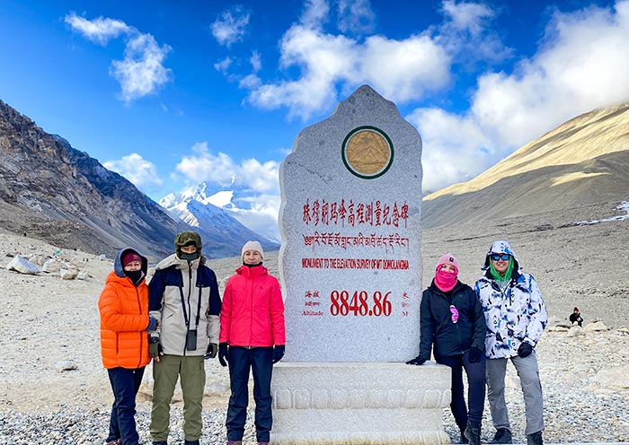
It normally takes 1-3 days to circle around Mt. Kailash by walking or performing body-length prostrations. For people with no religious background, walking the kora in the Kailash Mountain is a great challenge physically and psychologically. But after the whole journey, you will find yourself with the tranquil mind, and all the efforts are totally worthy.
The best time to trek along the Kailash Kora
April to October is the appropriate seasons for circling around the mountain. But the temperature in April, May and October is still low, and the path of the kora is still covered with white snow. Those, coupled with the strong sunshine, can make the journey even harder and tourists be sunburned. Besides, the temperature difference between day and night is huge during these months.
Therefore, it is advisable to walk the kora in Mt. Kailash in June to September. The most appropriate time is June and September. July and August is the rainy season in Tibet. But the rainfall in Ngari is much less than other areas in Tibet, therefore walking the kora in the two months is feasible.
Information you should know before starting the journey
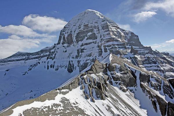
The highest altitude during the kora in Mt. Kailash is 5630 meters -- Drolma La Pass. That means to tourists need to finish the kora in the high altitude areas. Hence, if you have serious symptoms of altitude sickness even in Lhasa, you’d better not to start the kora. That would be quite dangerous.
If you feel strongly uncomfortable during the kora, it is advisable to stop the kora. Do not risk your own life.
The hardships of walking the kora in Mt. Kailash:
1. Far-reaching distance: departing from Lhasa, then passing Shigatse - Lhatse - Saga - Zhongba - Bayu - Darchen, one can finally arrive at the Mt. Kailash after the 1338-KM journey, which takes at least two days. Taking the Xinjiang-Tibet Route from Kashi to Tachin takes even longer with the whole journey being 1671 km. Of course, if you fly from Lhasa to Ngari Kunsha Airport, it takes much less time, but with a much higher cost.
2. Hiking altitude: The starting point of Darchen has an altitude of 4560 meters. The highest point in the process of kora is 5,630 meters above sea level.
3. The special characteristics of high-altitude hiking: during the kora, you will experience various challenges such as dizziness, difficulty in breathing, muscle aches, chapped lips, sunburn, etc. Physical exhaustion also requires perseverance. 4. Poor accommodation: no comfortable hotel during the walk, only humble guest houses.
Brief Introduction of the Kailash Yatra / Kora
The whole kora is 52 KM (aside from the distance to monasteries, 49KM). Among the whole journey, there are several landmarks, namely, Zhire Temple, Drolma La Pass( the highest point), and the Zunzhu Temple. Generally speaking, most people can complete the tour in two days. But due to different physical strength, there are different choices for walking the kora.
Darchen - 7KM - Seerxiong - 2.6KM - Qugu Temple Bridge - 4.5KM - Gesar Saddle Stone - 2.3KM - Tea House (Ma Tou Ming Wang Shi) - 4.2 KM——Xi Xia Bangma Hotel (opposite to Zheripu Temple River)——5.8KM——Drolma La Pass——2.6KM——The third Budongdiding (beside the tea house)——2.4KM—— the exit of the secret path - 3KM - Teahouse in the eastern section of Huanshan Road - 4.5KM - Zhongzhepu Temple - 6.2KM - Zongdui Tea House - 4KM - Darchen Town
How long does it take to finish the Kailash Yatra?
Option 1-One-day itinerary: suitable for local trekkers who have made several kora before and a few hiking ace (15 - 18 hours) Departure at 5:00-6:00 in the morning;
Arriving at the Zhire Temple around 12:00 noon;v At about 4:00 pm, trekking to the highest point of Drolma La Mountain Pass;
Returning to Darchen around 22:00 before dark.
Option 2-2-day itinerary: suitable for people without altitude sickness and are physically strong
Day1: Darchen - Zhire Temple (22 km, 6-10 hours)
Departure at 9:00 - 9:30 after breakfast;
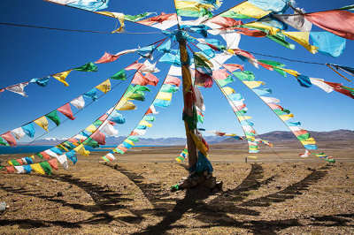
About one-hour climbing up to the top of the hill, where is covered with the colorful prayer flags;
About 1 hour walking downhill, you can arrive at the celestial burial ground;
Along the Laqu River, it takes about 3-4 hours to Zhire Temple, where the holy mountain can be seen on the east side;
Stay the overnight at Zhire Temple.
Day2: Zhire Temple - Darchen (34 km, 9-14 hours)
Departing at around 8:00, the section is of a high slope and the most difficult;
After 3-4 hours, you can trek up to the Drolma La Mountain Pass, where you can see a sea of prayer flags;
After 1 hour, you can arrive at the tent to rest and have lunch;
After 2-3 hours downhill to the Zuchu Temple;
After 3-4 hours downhill back to Darchen.
Option 3- 3-Day Itinerary: suitable for ramblers who are not in a hurry or the seniors and children.
We provide 14 days Mt. Kailash Trekking tour for those traveling alone or one a budget. You can refer to our group tour for more details.
Day1: Darchen - Zhire Temple (22 km)
Day2: Zhire Temple - Zutrupuk Temple (22 km)
Day3: Zutrupuk Temple - Darchen (12 km)
Detailed 3-day itinerary
D1: Darchen - Zhire Temple, 22 km
You’d better depart as early as possible after breakfast. Walking westward, you can see the path of the kora not before long. Then after one-hour walking uphill, you can reach the top of a hill, where is covered with colorful prayer flags. The holy mountain is visible from the hill. Then downhill, following the path northward to Laqu Canyon, and one hour later you can reach the two-legged stupa, one of the landmarks of Mount Kailash. It’s said that crossing under its two legs will receive God's blessing. The altitude there is 4,750 meters. There is a huge prayer column a few hundred meters to the east of the stupa. Every April 15th in the Tibetan Calendar, there is a grand ceremony for the regular replacement of the column.
If you plan to walk the kora in the Year of the Horse, don't miss this day. Then you will follow the path down to the bottom of the valley, with red cliffs on either side. The Qugu Temple (4820 meters above sea level),originally built in the 13th century, stands on the cliff in the middle of the west side. Under the cliff lies the Laqu River, a small bridge hanging across the river. From the bridge, you can climb to the temple. A precious statue in the glass cabinet above the altar in the temple is called Qugu. The statue come form India and is said to be able to speak. From here you can see the powerful west wall of Mt. Kailash. The mountain road is divided into two from the small bridge, respectively along the east and west sides of the Laqu River. Both roads lead to the Zhire Temple, taking about 3.5 hours to there. The road in the west bank is a little longer. The two roads are not steep, but the altitude has been rising slowly. On the north side of the Laqu River lies Zhire Temple, the name of which means the female yak horn hole. The temple is facing the glorious north wall of Mt. Kailash. You can stay overnight at the temple, costing 100 yuan / person. The first of the journey may be exhausting, given the steep mountain roads. D2: Zhire Temple - Zutrupuk Temple, 22 km, 8 hours
This is the day to test your perseverance and physical strength, with the altitude difference being 762 meters. In this day, you will reach the highest point of the journey -- Droma La Pass. Walking eastward from Zhire Temple, you will face with a steep slope at the very beginning. Then the winding path will lead you to the 5,330-meter celestial burial platform, the land of death, which is covered with clothes. The place where the path is narrowed by the large stones on both sides is called the test stone of sin. It is said that people with too many sins in the previous life cannot cross the test stone. En route there is a much-revered footprint of Milarepa, though, spotting it on your own is difficult. When the trail reaches the valley floor, you can recover over a sweet tea at a collection of teahouse tents. There's a public toilet here. A huge rock topped by the kora’s third Buddha footprint (shabje drakdo) stands just above (5245m).
As with the Lha-chu Valley on the western side of Mt Kailash, there are routes that follow both sides of the river. The main east-bank trail now follows an unpaved road and electricity lines, so consider sticking to the western side for some peace and quiet. About 30 minutes south, a valley comes down from the Khando Sanglam-la to join the western trail. This valley provides only the briefest glimpse of Mt Kailash’s eastern or crystal face. The kora’s third prostration point is at the valley mouth, but it’s easily missed.
Grassy fields start to appear alongside the river, affording those with tents endless spots to set up camp. In the meantime the road crosses to the western side of the valley, passing a teahouse and derelict accommodation at Sangye Menlong. A side valley enters from the left. Zutul-puk Monastery (4820m) is a further 30 minutes' walk, a wearisome two hours' walk from the Buddha footprint teahouses. The zutul puk (miracle cave) that gives the monastery its name is at the back of the main hall. The best place to stay is the Zutul-puk Monastery Guesthouse, with five-bed rooms set around a warm greenhouse-style solarium. A large new government guesthouse is under construction
D3: Zutrulpuk - Darchen, 11.3 km, 3 hours
You can visit the Zutrulpuk Monastery in the morning. From the monastery the trail follows the river closely for an hour or so, then climbs above the river and enters the striking Gold and Red Cliffs, a narrow canyon whose walls are stained purple, cobalt and rust. When the canyon narrows, look for holes gouged into the cliff walls. These are not natural but were made by pilgrims looking for holy stones. Where the trail emerges onto the Barkha plain, close to the fourth prostration point (4700m) at Dzongdoe, Gurla Mandata is again visible in the distance. It’s now an easy one-hour walk back to Darchen along a dirt road. While this is not a very scenic stretch of the kora, the steady ground below does allow you to drift off and reflect on the past three days.
The change of altitudes during the kora in Mt. Kailash
The elevation map of the kora in the Mount Kailash shows a pyramid shape. The starting point of Darchen is relatively low, about 4675 meters. Then the altitude gradually rises until reaching the highest point of the Drolma La Mountain Pass, 5660 meters above sea level. Then the altitude shows a gradual decline until it returns to the town of Darchen.
Where to stay while trekking at Mt. Kailash?
During the kora, you can stay overnight at the Zhire Temple and Zutrulpuk Monastery, where the conditions are very limited. If you are concerned about the sanitary conditions, it is recommended to bring your own sleeping bag. The food
There are tea houses on the way. After arriving at the teahouse, you can order a pot of butter tea, and take a rest there and get yourself warmer as soon as possible. There are about 7-8 places selling food and supplying hot water along the way. (Instant noodles: 10 yuan / box, Red Bull: 10 yuan / can, mineral water: 6 yuan / bottle, butter tea: 10 yuan / pot, hot water free)
The food is simple and expensive, so you’d better bring some dry food with you.
How to hire a yak/porter and how much does it cost
On the day before the kora, tourists can hire a porter, a yak, or a horse to hump their luggage with the help of a tour guide. If you don’t have too much baggage, you can carry it yourself.
Yak: 340 yuan / day / head
Porter: 380 yuan / day / person
Horse: 410 yuan / person / horse
What documents are needed for trekking the kora in Ngari Prefecture?
Foreign tourists walking the kora in Ngari Prefecture need to apply for the following documents through the travel agency: Tibet Entry Permit, Border Pass, Military Pass, and Tibet Travel Permit.
Due to the large number of documents that need to be processed, you need to book the tour at least one month in advance, if you plan to visit Ngari Prefecture.
What equipment needed for finish the kora in Mt.Kailash?
Clothing
From June to September, the climate in Ngari is pleasant, but the temperature difference between morning and evening is large. Two jackets with waterproof fabrics are needed.The weather in the high-altitude areas changes rapidly. It is also necessary to wear breathable waterproof walking pants. It is recommended not to wear fleece pants, cause during the day it may be too hot. You’d better wear hiking shoes that are one size larger than your own feet, because many people’ feet may get oedematous after a day of walking. On top of those, a pair of comfortable cotton socks are also essential.
Backpack
You can prepare the backpack according to the trekking days. If you want to complete the kora in a day, you can a lightweight backpack with 30L. If you plan to complete the kora two days and more, you need to prepare a bigger backpack, but no bigger than 50L. In addition to the backpack, it is recommended to prepare a waist bag, so that it is convenient to take mobile phones, sunscreens, etc.
Please refer to the packing list for more essential items.
How to avoid altitude sickness and how to deal with altitude sickness?
Many travelers may be worried about their physical condition, given such a long journey in the high altitude areas. The altitude of Darchen is 4,575 meters, and the highest point in the kora is 5,630 meters. Trekking to 5600 meters high on foot is definitely different from passing 5600-meter height by car. Therefore, you should pay enough attention to possible physical discomfort.
In fact, at high altitudes, most people would be uncomfortable even without the suffering from altitude sickness, given the thin air. Hence, you’d better move slowly lest you have a headache.
If you show severe symptoms of altitude sickness, you shall use the oxygen cylinder in time and evacuate to low-altitude areas as soon as possible.